
Rindge topographic map
Interactive map
Click on the map to display elevation.
About this map
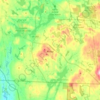
Name: Rindge topographic map, elevation, terrain.
Location: Rindge, Cheshire County, New Hampshire, United States (42.71216 -72.09185 42.79370 -71.92886)
Average elevation: 343 m
Minimum elevation: 255 m
Maximum elevation: 481 m
According to the United States Census Bureau, the town has a total area of 39.8 square miles (103.1 km2), of which 37.1 square miles (96.1 km2) are land and 2.7 square miles (7.0 km2) are water, comprising 6.76% of the town. Rindge is located in a hilly upland lake region. Hubbard Pond is in the northeast, Contoocook Lake on the northern boundary, Pearly Lake is in the northwest, and Lake Monomonac is on the southern boundary. The town is located on a regional watershed divide and is the headwaters for two river systems. The Contoocook River flows north to the Merrimack River, thence to the Gulf of Maine, and the North Branch of the Millers River flows southwest to the Connecticut River, thence to Long Island Sound. Rindge's highest point is on its eastern border, on the lower slopes of Pratt Mountain, where the elevation reaches 1,505 feet (459 m) above sea level.
Other topographic maps
Click on a map to view its topography, its elevation and its terrain.
Keene
United States > New Hampshire > Cheshire County
Keene, Cheshire County, New Hampshire, United States
Average elevation: 263 m
North Swanzey
United States > New Hampshire > Cheshire County > Keene > North Swanzey
North Swanzey, Keene, Cheshire County, New Hampshire, 03435, United States
Average elevation: 169 m
Jaffrey
United States > New Hampshire > Cheshire County
Jaffrey, Cheshire County, New Hampshire, 03452, United States
Average elevation: 351 m
Harrisville
United States > New Hampshire > Cheshire County
Harrisville, Cheshire County, New Hampshire, 03450, United States
Average elevation: 422 m