Geolocate

Bodmin topographic map

Click on the map to display elevation.

About this map

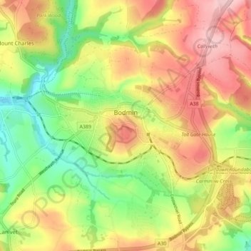
Name: Bodmin topographic map, elevation, terrain.

Location: Bodmin, Cornwall, England, United Kingdom (50.44937 -4.75914 50.48616 -4.67292)

Average elevation: 104 m

Minimum elevation: 11 m

Maximum elevation: 198 m

Other topographic maps

Click on a map to view its topography, its elevation and its terrain.

Darite

United Kingdom > England > Cornwall > St Cleer

Average elevation: 236 m

Pengold

United Kingdom > England > Cornwall > St Gennys

Average elevation: 135 m

Port Isaac

United Kingdom > England > Cornwall

Average elevation: 43 m

Gunnislake

United Kingdom > England > Cornwall

Average elevation: 109 m

Thank you for supporting this site ❤️
Make a donation

Gear up for your next adventure:

As an Amazon Associate, this site earns from qualifying purchases at no extra cost to you.

Bridgetown

United Kingdom > England > Cornwall

Average elevation: 93 m

Pengrugla

United Kingdom > England > Cornwall > Pengrugla

Average elevation: 66 m

Minions

United Kingdom > England > Cornwall > Minions

Average elevation: 265 m

Gwinear

United Kingdom > England > Cornwall

Average elevation: 65 m

Lerryn

United Kingdom > England > Cornwall

Average elevation: 60 m

Gear up for your next adventure:

📕Australia Maps - Maps covering Australian regions
📦Crushproof Equipment Cases - Safe transport for sensitive surveying and mapping instruments
🧥Insulated Down Jackets - High warmth-to-weight ratio for cold nights in the high country
💧Personal Water Filters - Drink safely from streams and lakes identified on your map
🍳Ultralight Camping Stoves - Boil water quickly for meals using minimal fuel

As an Amazon Associate, this site earns from qualifying purchases at no extra cost to you.