
Hawthorne topographic map
Interactive map
Click on the map to display elevation.
About this map
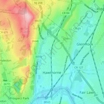
Name: Hawthorne topographic map, elevation, terrain.
Location: Hawthorne, Passaic County, New Jersey, United States (40.93433 -74.17159 40.98387 -74.14105)
Average elevation: 62 m
Minimum elevation: 9 m
Maximum elevation: 184 m
Other topographic maps
Click on a map to view its topography, its elevation and its terrain.
Bloomingdale
United States > New Jersey > Passaic County
Bloomingdale, Passaic County, New Jersey, 07403, United States
Average elevation: 157 m
North Haledon
United States > New Jersey > Passaic County
North Haledon, Passaic County, New Jersey, 07508, United States
Average elevation: 132 m
Clinton
United States > New Jersey > Passaic County > West Milford
Clinton, West Milford, Passaic County, New Jersey, 07435, United States
Average elevation: 292 m
Haledon
United States > New Jersey > Passaic County > Haledon
Haledon, Passaic County, New Jersey, United States
Average elevation: 81 m
Clifton
United States > New Jersey > Passaic County
Clifton, Passaic County, New Jersey, United States
Average elevation: 56 m