Geolocate

Kent topographic map

Click on the map to display elevation.

About this map

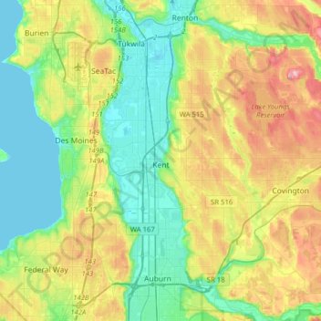
Name: Kent topographic map, elevation, terrain.

Location: Kent, King County, Washington, United States (47.34351 -122.30941 47.44122 -121.99596)

Average elevation: 88 m

Minimum elevation: 0 m

Maximum elevation: 323 m

Other topographic maps

Click on a map to view its topography, its elevation and its terrain.

Somerset

United States > Washington > King County > Bellevue

Average elevation: 131 m

Riverton

United States > Washington > King County > Tukwila

Average elevation: 77 m

Gear up for your next adventure:

🦶Orthotic Hiking Insoles - Extra arch support for long-distance topographic treks
Altimeter Watches - Watches with altitude tracking
🍳Ultralight Camping Stoves - Boil water quickly for meals using minimal fuel
🔋Solar Power Banks - Charge your phone and GPS using the sun while deep in the bush
🔦Powerful LED Headlamps - Hands-free lighting for night navigation and setting up camp after dark

As an Amazon Associate, this site earns from qualifying purchases at no extra cost to you.