
Make a donation
Gear up for your next adventure:
As an Amazon Associate, this site earns from qualifying purchases at no extra cost to you.
Colón topographic map
Click on the map to display elevation.
Make a donation
Gear up for your next adventure:
As an Amazon Associate, this site earns from qualifying purchases at no extra cost to you.
Colón
La altura de Colón es de 2215 metros en el perímetro urbano, pero en la zona montañosa de la cima alcanza los 2800 msnm. La precipitación media anual es de 1580mm; la humedad relativa media anual es de 80%. La topografía es plana ondulada hacia la cabera municipal y a la veredas aledañas y montañosas hacia la veredas: Rejoya, Rundiyaco, Vergel de Fátima, Villa Nazareth.
Make a donation
Gear up for your next adventure:
As an Amazon Associate, this site earns from qualifying purchases at no extra cost to you.
About this map
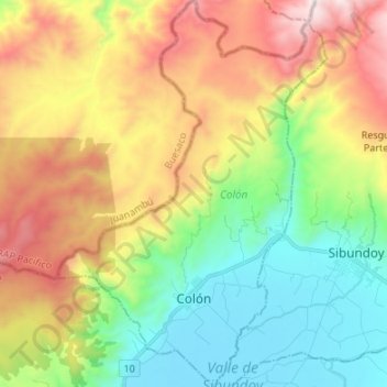
Name: Colón topographic map, elevation, terrain.
Location: Colón, Putumayo, RAP Amazonía, Colombia (1.15862 -77.02095 1.29312 -76.92595)
Average elevation: 2,569 m
Minimum elevation: 2,058 m
Maximum elevation: 3,355 m
Make a donation
Gear up for your next adventure:
As an Amazon Associate, this site earns from qualifying purchases at no extra cost to you.
Other topographic maps
Click on a map to view its topography, its elevation and its terrain.
Make a donation
Gear up for your next adventure:
As an Amazon Associate, this site earns from qualifying purchases at no extra cost to you.