
Make a donation
Gear up for your next adventure:
As an Amazon Associate, this site earns from qualifying purchases at no extra cost to you.
Addis Ababa topographic map
Click on the map to display elevation.
Make a donation
Gear up for your next adventure:
As an Amazon Associate, this site earns from qualifying purchases at no extra cost to you.
Addis Ababa
Moreover, the city held strong social organization patterns prior to the Italian invasion. According to Richard Pankhurst (1968), the city's accelerated population growth was due to factors of provisional governors and their troops, the 1892 famine, and eventually the Battle of Adwa. Another includes the 1907 land act, municipal administration in 1909, and a railway and modernized transportation system boom beginning in the 20th century, culminating in continual growth. Additional supplements, for example the laying of Ethio-Djibouti Railways and topographical factors further led the city's boundary to expand southward.
Make a donation
Gear up for your next adventure:
As an Amazon Associate, this site earns from qualifying purchases at no extra cost to you.
About this map
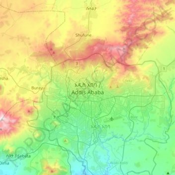
Name: Addis Ababa topographic map, elevation, terrain.
Location: Addis Ababa, Arada, Addis Ababa, 3578, Ethiopia (8.87583 38.59241 9.19583 38.91241)
Average elevation: 2,517 m
Minimum elevation: 2,058 m
Maximum elevation: 3,383 m
Make a donation
Gear up for your next adventure:
As an Amazon Associate, this site earns from qualifying purchases at no extra cost to you.