
Kraków County topographic map
Interactive map
Click on the map to display elevation.
About this map
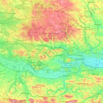
Name: Kraków County topographic map, elevation, terrain.
Location: Kraków County, Lesser Poland Voivodeship, Poland (49.88519 19.52039 50.31465 20.35376)
Average elevation: 307 m
Minimum elevation: 191 m
Maximum elevation: 559 m
Other topographic maps
Click on a map to view its topography, its elevation and its terrain.
Olkusz County
Poland > Lesser Poland Voivodeship
Olkusz County, Lesser Poland Voivodeship, Poland
Average elevation: 365 m
Mogilany
Poland > Lesser Poland Voivodeship > Kraków County
Mogilany, gmina Mogilany, Kraków County, Lesser Poland Voivodeship, 32-031, Poland
Average elevation: 312 m
Skawina
Poland > Lesser Poland Voivodeship > Kraków County
Skawina, gmina Skawina, Kraków County, Lesser Poland Voivodeship, Poland
Average elevation: 238 m
Libertów
Poland > Lesser Poland Voivodeship > Kraków County
Libertów, gmina Mogilany, Kraków County, Lesser Poland Voivodeship, 30-444, Poland
Average elevation: 270 m
Krakow
Poland > Lesser Poland Voivodeship
Krakow, Lesser Poland Voivodeship, Poland
Average elevation: 263 m
Nowy Targ County
Poland > Lesser Poland Voivodeship
Nowy Targ County, Lesser Poland Voivodeship, Poland
Average elevation: 757 m
Tatra County
Poland > Lesser Poland Voivodeship
Tatra County, Lesser Poland Voivodeship, Poland
Average elevation: 1,105 m
Sucha County
Poland > Lesser Poland Voivodeship
Sucha County, Lesser Poland Voivodeship, Poland
Average elevation: 593 m
Wilga
Poland > Lesser Poland Voivodeship > Krakow
Wilga, Krakow, Lesser Poland Voivodeship, 30-419, Poland
Average elevation: 222 m
Morskie Oko
Poland > Lesser Poland Voivodeship > Brzegi
Morskie Oko, Droga Oswalda Balzera, Brzegi, gmina Bukowina Tatrzańska, Tatra County, Lesser Poland Voivodeship, Poland
Average elevation: 1,749 m
Oświęcim
Poland > Lesser Poland Voivodeship > Oświęcim
Oświęcim, powiat oświęcimski, Lesser Poland Voivodeship, Poland
Average elevation: 239 m
Sucha Beskidzka
Poland > Lesser Poland Voivodeship > Sucha County > Sucha Beskidzka
Sucha Beskidzka, Sucha County, Lesser Poland Voivodeship, Poland
Average elevation: 497 m