
Siston topographic map
Interactive map
Click on the map to display elevation.
About this map
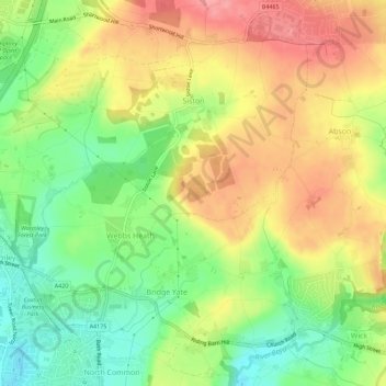
Name: Siston topographic map, elevation, terrain.
Average elevation: 80 m
Minimum elevation: 32 m
Maximum elevation: 128 m
Other topographic maps
Click on a map to view its topography, its elevation and its terrain.
Kingswood
United Kingdom > England > South Gloucestershire
Kingswood, South Gloucestershire, West of England, England, BS15 8LQ, United Kingdom
Average elevation: 57 m
Patchway
United Kingdom > England > South Gloucestershire
Patchway, South Gloucestershire, West of England, England, BS34 5PW, United Kingdom
Average elevation: 50 m
Woodmancote
United Kingdom > England > South Gloucestershire > Dursley
Woodmancote, Dursley, Stroud, South Gloucestershire, England, GL11 4BD, United Kingdom
Average elevation: 130 m