
Make a donation
Gear up for your next adventure:
As an Amazon Associate, this site earns from qualifying purchases at no extra cost to you.
Almancil topographic map
Click on the map to display elevation.
Make a donation
Gear up for your next adventure:
As an Amazon Associate, this site earns from qualifying purchases at no extra cost to you.
Almancil
Due to an influx of tourism into the Algarve, the resident population of the parish expanded, resulting in the 18 December 1987 elevation of the parish to category of town.
Make a donation
Gear up for your next adventure:
As an Amazon Associate, this site earns from qualifying purchases at no extra cost to you.
About this map
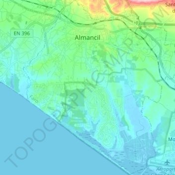
Name: Almancil topographic map, elevation, terrain.
Location: Almancil, Loulé, Faro, Portugal (37.01048 -8.07474 37.10797 -7.96478)
Average elevation: 29 m
Minimum elevation: -3 m
Maximum elevation: 216 m
Make a donation
Gear up for your next adventure:
As an Amazon Associate, this site earns from qualifying purchases at no extra cost to you.
Other topographic maps
Click on a map to view its topography, its elevation and its terrain.
Barão de São João
Portugal > Faro > Bensafrim e Barão de São João > Barão de São João
Average elevation: 88 m