
Silverstone topographic map
Click on the map to display elevation.
About this map
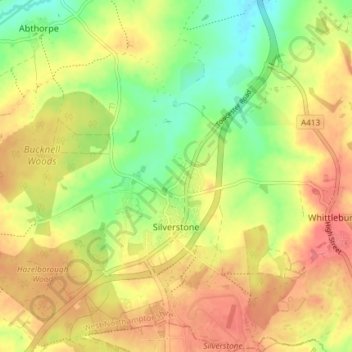
Name: Silverstone topographic map, elevation, terrain.
Location: Silverstone, West Northamptonshire, England, United Kingdom (52.07159 -1.05758 52.11693 -0.99845)
Average elevation: 133 m
Minimum elevation: 94 m
Maximum elevation: 166 m
Other topographic maps
Click on a map to view its topography, its elevation and its terrain.
Lower Thorpe
United Kingdom > England > West Northamptonshire > Thorpe Mandeville
Average elevation: 154 m
Ravensthorpe Reservoir
United Kingdom > England > West Northamptonshire > Coton
Average elevation: 131 m