
Santa Barbara topographic map
Click on the map to display elevation.
Santa Barbara
Annual rainfall totals are highly variable and in exceptional years (like 1940–1941 and 1997–1998) over 40 inches (1,000 mm) of rain have fallen in a year, but in dry seasons less than 6 inches (150 mm) is not unheard of. Snow sometimes covers higher elevations of the Santa Ynez Mountains but is extremely rare in the city itself. The most recent accumulating snow to fall near sea level was in January 1949, when approximately 2 inches (5.1 cm) fell in the city.
About this map
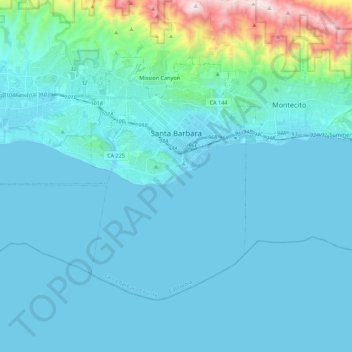
Name: Santa Barbara topographic map, elevation, terrain.
Average elevation: 119 m
Minimum elevation: -1 m
Maximum elevation: 1,155 m
Other topographic maps
Click on a map to view its topography, its elevation and its terrain.
Vandenberg Village
United States > California > Santa Barbara County > Lompoc
Average elevation: 132 m
North Santa Maria
United States > California > Santa Barbara County > Santa Maria
Average elevation: 65 m
Jalama Beach County Park
United States > California > Santa Barbara County > Jalama
Average elevation: 40 m
North Santa Maria
United States > California > Santa Barbara County > Santa Maria
Average elevation: 65 m
Shoreline Park
United States > California > Santa Barbara County > Santa Barbara
Average elevation: 21 m