
Make a donation
Gear up for your next adventure:
As an Amazon Associate, this site earns from qualifying purchases at no extra cost to you.
Schöffau topographic map
Click on the map to display elevation.
Make a donation
Gear up for your next adventure:
As an Amazon Associate, this site earns from qualifying purchases at no extra cost to you.
About this map
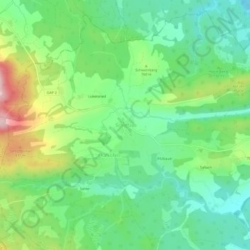
Name: Schöffau topographic map, elevation, terrain.
Average elevation: 729 m
Minimum elevation: 645 m
Maximum elevation: 895 m
Make a donation
Gear up for your next adventure:
As an Amazon Associate, this site earns from qualifying purchases at no extra cost to you.
Other topographic maps
Click on a map to view its topography, its elevation and its terrain.
Garmisch-Partenkirchen
Germany > Bavaria > Landkreis Garmisch-Partenkirchen
Garmisch-Partenkirchen leans towards an oceanic climate, and its winters are colder than the rest of Bavaria. Due to its higher elevation, it is very close to the winters associated with continental climates; it has a relatively wet and snowy climate, with high precipitation year-round.
Average elevation: 1,326 m
Garmisch-Partenkirchen
Germany > Bavaria > Landkreis Garmisch-Partenkirchen
Garmisch-Partenkirchen leans towards an oceanic climate, and its winters are colder than the rest of Bavaria. Due to its higher elevation, it is very close to the winters associated with continental climates; it has a relatively wet and snowy climate, with high precipitation year-round. As of 2013 the regions…
Average elevation: 1,326 m
Make a donation
Gear up for your next adventure:
As an Amazon Associate, this site earns from qualifying purchases at no extra cost to you.
Königshaus am Schachen
Germany > Bavaria > Landkreis Garmisch-Partenkirchen > Garmisch-Partenkirchen
The King's House on Schachen is located at Schachen, at an altitude with a view of the dramatic mountain backdrop of the Wetterstein Formation, about 10 km south of Garmisch-Partenkirchen, Bavaria. It can only be reached via a 10 km forest road, or a three-hour hike, ascending 1000m either from Schloss Elmau…
Average elevation: 1,629 m
Garmisch-Partenkirchen
Germany > Bavaria > Landkreis Garmisch-Partenkirchen
Garmisch-Partenkirchen leans towards an oceanic climate, and its winters are colder than the rest of Bavaria. Due to its higher elevation, it is very close to the winters associated with continental climates; it has a relatively wet and snowy climate, with high precipitation year-round. As of 2013 the regions…
Average elevation: 1,326 m
Make a donation
Gear up for your next adventure:
As an Amazon Associate, this site earns from qualifying purchases at no extra cost to you.
Rießersee
Germany > Bavaria > Landkreis Garmisch-Partenkirchen > Garmisch-Partenkirchen
Average elevation: 845 m
Partnach Gorge
Germany > Bavaria > Landkreis Garmisch-Partenkirchen > Garmisch-Partenkirchen > Vordergraseck
Average elevation: 1,004 m
Make a donation
Gear up for your next adventure:
As an Amazon Associate, this site earns from qualifying purchases at no extra cost to you.
Geroldsee (Wagenbrüchsee)
Germany > Bavaria > Landkreis Garmisch-Partenkirchen > Gerold
Average elevation: 1,040 m
Make a donation
Gear up for your next adventure:
As an Amazon Associate, this site earns from qualifying purchases at no extra cost to you.