
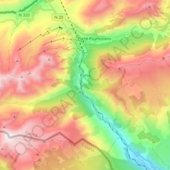
Porta topographic map
Interactive map
Click on the map to display elevation.
About this map
Name: Porta topographic map, elevation, terrain.
Average elevation: 2,089 m
Minimum elevation: 1,262 m
Maximum elevation: 2,907 m
Other topographic maps
Click on a map to view its topography, its elevation and its terrain.
Perpignan
France > Occitania > Pyrénées-Orientales
Perpignan, Pyrénées-Orientales, Occitania, Metropolitan France, France
Average elevation: 38 m
Saint-Paul-de-Fenouillet
France > Occitania > Pyrénées-Orientales
Saint-Paul-de-Fenouillet, Prades, Pyrénées-Orientales, Occitania, Metropolitan France, 66220, France
Average elevation: 427 m
Montescot
France > Occitania > Pyrénées-Orientales
Montescot, Céret, Pyrénées-Orientales, Occitania, Metropolitan France, 66200, France
Average elevation: 16 m
Elne
France > Occitania > Pyrénées-Orientales > Elne
Elne, Céret, Pyrénées-Orientales, Occitania, Metropolitan France, 66200, France
Average elevation: 14 m
Corsavy
France > Occitania > Pyrénées-Orientales > Corsavy
Corsavy, Céret, Pyrénées-Orientales, Occitania, Metropolitan France, 66150, France
Average elevation: 1,378 m
Font-Romeu-Odeillo-Via
France > Occitania > Pyrénées-Orientales
Font-Romeu-Odeillo-Via, Prades, Pyrénées-Orientales, Occitania, Metropolitan France, 66120, France
Average elevation: 1,733 m