
Glacier Bay National Park topographic map
Interactive map
Click on the map to display elevation.
About this map
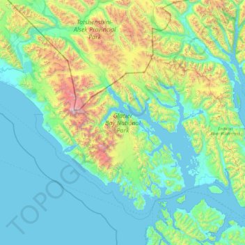
Name: Glacier Bay National Park topographic map, elevation, terrain.
Average elevation: 572 m
Minimum elevation: -3 m
Maximum elevation: 4,578 m
Other topographic maps
Click on a map to view its topography, its elevation and its terrain.
Delta Road
United States of America > Alaska > King Cove
Delta Road, King Cove, Aleutians East, Alaska, United States of America
Average elevation: 119 m
Denali National Park and Preserve
United States of America > Alaska
Denali National Park and Preserve, Alaska, United States of America
Average elevation: 777 m