
Ilkley topographic map
Interactive map
Click on the map to display elevation.
About this map
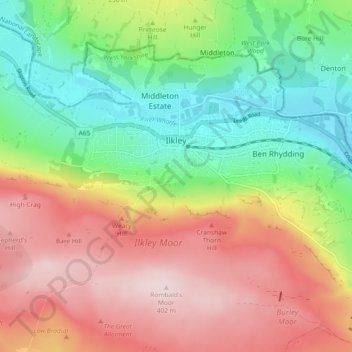
Name: Ilkley topographic map, elevation, terrain.
Location: Ilkley, Bradford, West Yorkshire, England, United Kingdom (53.89957 -1.86948 53.94076 -1.77753)
Average elevation: 221 m
Minimum elevation: 64 m
Maximum elevation: 402 m
Other topographic maps
Click on a map to view its topography, its elevation and its terrain.
Harden
United Kingdom > England > Bradford > Harden
Harden, Bradford, West Yorkshire, England, United Kingdom
Average elevation: 198 m
Baildon
United Kingdom > England > Bradford > Baildon
Baildon, Bradford, West Yorkshire, England, United Kingdom
Average elevation: 147 m
Middle Brook
United Kingdom > England > Bradford
Middle Brook, Bradford, Yorkshire and the Humber, England, BD8 0ES, United Kingdom
Average elevation: 170 m
Fernshaw Hill
United Kingdom > England > Bradford
Fernshaw Hill, Bradford, Yorkshire and the Humber, England, BD20 7BE, United Kingdom
Average elevation: 308 m