Geolocate

Pace topographic map

Click on the map to display elevation.

About this map

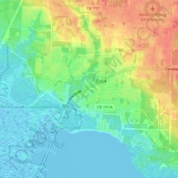
Name: Pace topographic map, elevation, terrain.

Location: Pace, Santa Rosa County, Florida, United States (30.56911 -87.20465 30.62373 -87.13046)

Average elevation: 17 m

Minimum elevation: -4 m

Maximum elevation: 49 m

Gear up for your next adventure:

🎒Hiking Backpacks - Backpacks designed for hiking and trekking
🔋Solar Power Banks - Charge your phone and GPS using the sun while deep in the bush
🔪Multitools - Compact tools for outdoor use
📱Tablet Tripod Mounts - Steady platforms for viewing digital maps or taking long exposures
🦟Heavy Duty Insect Repellent - Essential protection against flies, mozzies, and march flies

As an Amazon Associate, this site earns from qualifying purchases at no extra cost to you.