Gorzów County topographic map
Click on the map to display elevation.
About this map

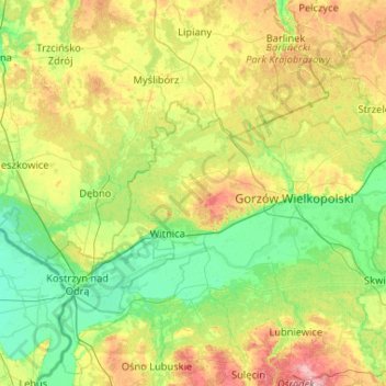
Name: Gorzów County topographic map, elevation, terrain.
Location: Gorzów County, Lubusz Voivodeship, Poland (52.57215 14.56403 52.90511 15.60619)
Average elevation: 58 m
Minimum elevation: 4 m
Maximum elevation: 205 m
Other topographic maps
Click on a map to view its topography, its elevation and its terrain.


Nowa Sól
Poland > Lubusz Voivodeship > Nowa Sól County
Nowa Sól, Nowa Sól County, Lubusz Voivodeship, Poland
Average elevation: 67 m

Sulęcin
Sulęcin, gmina Sulęcin, powiat sulęciński, Lubusz Voivodeship, 69-200, Poland
Average elevation: 96 m
