
Carmunnock topographic map
Interactive map
Click on the map to display elevation.
About this map
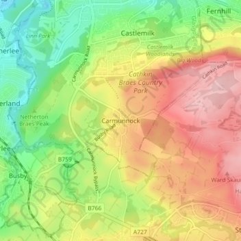
Name: Carmunnock topographic map, elevation, terrain.
Location: Carmunnock, Glasgow City, Scotland, G76 9BX, United Kingdom (55.77071 -4.25542 55.81071 -4.21542)
Average elevation: 120 m
Minimum elevation: 37 m
Maximum elevation: 209 m
Other topographic maps
Click on a map to view its topography, its elevation and its terrain.
Glasgow
United Kingdom > Scotland > Glasgow City
Glasgow, Glasgow City, Scotland, G2 1DY, United Kingdom
Average elevation: 128 m