
Lake Lilla topographic map
Interactive map
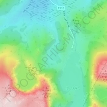
Click on the map to display elevation.
About this map
Name: Lake Lilla topographic map, elevation, terrain.
Average elevation: 1,009 m
Minimum elevation: 869 m
Maximum elevation: 1,286 m
Other topographic maps
Click on a map to view its topography, its elevation and its terrain.
Cradle Mountain
Australia > Tasmania > Cradle Mountain
Cradle Mountain, Cradle Mount Summit Track, Cradle Mountain, Meander Valley, Tasmania, Australia
Average elevation: 1,144 m
Dove Lake
Australia > Tasmania > Cradle Mountain
Dove Lake, Cradle Mountain, Kentish, Tasmania, Australia
Average elevation: 1,060 m