
Make a donation
Gear up for your next adventure:
As an Amazon Associate, this site earns from qualifying purchases at no extra cost to you.
Rochester Hills topographic map
Click on the map to display elevation.
Make a donation
Gear up for your next adventure:
As an Amazon Associate, this site earns from qualifying purchases at no extra cost to you.
Rochester Hills
Rochester Hills is bordered to the north by Oakland Charter Township along Dutton Road, to the south by the city of Troy along South Boulevard, to the east by Shelby Township in Macomb County along Dequindre Road, and to the west by the city of Auburn Hills along part of Adams Road. Rochester Hills is also partially bordered by the city of Rochester to the east. Elevations in the city range from 690 feet (210 m) above sea level in the southeastern portion of the city to 1,032 feet (315 m) in the northwestern section.
Make a donation
Gear up for your next adventure:
As an Amazon Associate, this site earns from qualifying purchases at no extra cost to you.
About this map
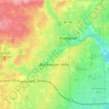
Name: Rochester Hills topographic map, elevation, terrain.
Location: Rochester Hills, Oakland County, Michigan, United States (42.62100 -83.21378 42.71249 -83.09144)
Average elevation: 250 m
Minimum elevation: 200 m
Maximum elevation: 318 m
Make a donation
Gear up for your next adventure:
As an Amazon Associate, this site earns from qualifying purchases at no extra cost to you.