Geolocate

Sibulan topographic map

Click on the map to display elevation.

About this map

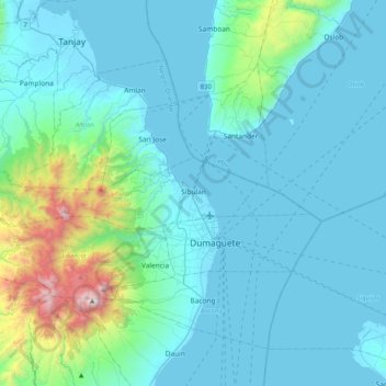
Name: Sibulan topographic map, elevation, terrain.

Location: Sibulan, Negros Oriental, Central Visayas, 6201, Philippines (9.31935 123.00174 9.39503 123.41008)

Average elevation: 217 m

Minimum elevation: 0 m

Maximum elevation: 1,822 m

Other topographic maps

Click on a map to view its topography, its elevation and its terrain.

Vallehermoso

Philippines > Negros Oriental

Average elevation: 69 m

Gear up for your next adventure:

🛌Sleeping Mats - Insulated mats for camping comfort
🧥Down Jackets - Insulated jackets for cold weather
🔥Windproof Plasma Lighters - USB rechargeable lighters that work in high-altitude winds
🎒Daypacks - Compact backpacks for short hikes
🧭Global Orienteering Compass - High-precision liquid-filled compasses for accurate map reading and navigation

As an Amazon Associate, this site earns from qualifying purchases at no extra cost to you.