Geolocate

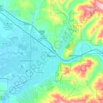
Missoula topographic map

Click on the map to display elevation.

Missoula

Missoula is located at the western edge of Montana, less than 25 miles (40 km) from the Idaho border as the crow flies. By highway it is 117 miles (188 km) south of Kalispell, 118 miles (190 km) northwest of Butte and 165 miles (266 km) southeast of Coeur d'Alene, Idaho. The city is at an elevation of 3,209 feet (978 m) above sea level, with nearby Mount Sentinel and Mount Jumbo steeply rising to 5,158 feet (1,572 m) and 4,768 feet (1,453 m), respectively. According to the U.S. Census Bureau's 2023 figures, the city had a total area of 35.0 square miles (90.6 km2), of which 34.8 square miles (90.1 km2) were land and 0.2 square miles (0.5 km2), or 0.54%, were covered by water.

Wikipedia (CC-BY-SA 3.0)

About this map

Name: Missoula topographic map, elevation, terrain.

Location: Missoula, Missoula County, Montana, United States (46.79154 -114.12729 46.94995 -113.89732)

Average elevation: 1,173 m

Minimum elevation: 943 m

Maximum elevation: 2,021 m

Other topographic maps

Click on a map to view its topography, its elevation and its terrain.

Huston

United States > Montana > Missoula County

Average elevation: 2,321 m

Lolo Hot Springs

United States > Montana > Missoula County

Average elevation: 1,377 m

Pinegrove

United States > Montana > Missoula County > East Missoula

Average elevation: 1,155 m

Huson

United States > Montana > Missoula County

Average elevation: 958 m

Huston

United States > Montana > Missoula County

Average elevation: 2,321 m

Miller Peak

United States > Montana > Missoula County

Average elevation: 1,835 m

Huston

United States > Montana > Missoula County

Average elevation: 2,321 m

Riata Park

United States > Montana > Missoula County > Missoula

Average elevation: 961 m

Gear up for your next adventure:

🥤Hydration Packs - Hydration systems for hiking
🆘Personal Locator Beacons (PLB) - Satellite emergency beacons for life-saving help in areas with no mobile coverage
📚Map Reading & Navigation Guides - Master the art of interpreting topographic contours and symbols
👕UPF 50+ Sun Shirts - Essential protection against the harsh Australian sun during field work
🔋Solar Power Banks - Charge your phone and GPS using the sun while deep in the bush

As an Amazon Associate, this site earns from qualifying purchases at no extra cost to you.