
Make a donation
Gear up for your next adventure:
As an Amazon Associate, this site earns from qualifying purchases at no extra cost to you.
Lendorf topographic map
Click on the map to display elevation.
Make a donation
Gear up for your next adventure:
As an Amazon Associate, this site earns from qualifying purchases at no extra cost to you.
About this map
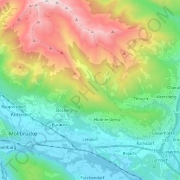
Name: Lendorf topographic map, elevation, terrain.
Location: Lendorf, Bezirk Spittal an der Drau, Carinthia, 9811, Austria (46.81048 13.37796 46.91256 13.47917)
Average elevation: 1,235 m
Minimum elevation: 537 m
Maximum elevation: 2,742 m
Make a donation
Gear up for your next adventure:
As an Amazon Associate, this site earns from qualifying purchases at no extra cost to you.
Other topographic maps
Click on a map to view its topography, its elevation and its terrain.
Pasterze
Austria > Carinthia > Bezirk Spittal an der Drau > Heiligenblut am Großglockner
Average elevation: 2,599 m
Bach
Austria > Carinthia > Bezirk Spittal an der Drau > Bad Kleinkirchheim > Bach
Average elevation: 1,348 m