
Andover topographic map
Interactive map
Click on the map to display elevation.
Andover
Ragged Mountain, elevation 2,286 feet (697 m) above sea level, is on the northern boundary. The northern slopes of Mount Kearsarge occupy the southernmost part of town and contain the town's highest point, 2,460 ft (750 m) above sea level.
About this map
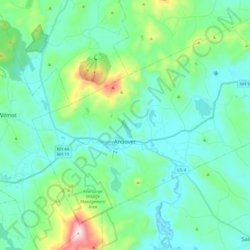
Name: Andover topographic map, elevation, terrain.
Location: Andover, Merrimack County, New Hampshire, United States (43.38902 -71.89415 43.50299 -71.69456)
Average elevation: 301 m
Minimum elevation: 164 m
Maximum elevation: 886 m
Other topographic maps
Click on a map to view its topography, its elevation and its terrain.
Waterloo
United States > New Hampshire > Merrimack County > Warner > Waterloo
Average elevation: 213 m