
Logan City topographic map
Interactive map
Click on the map to display elevation.
About this map
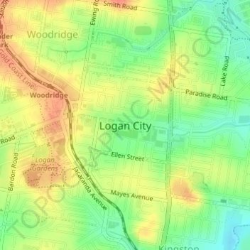
Name: Logan City topographic map, elevation, terrain.
Location: Logan City, Queensland, 4114, Australia (-27.64246 153.11305 -27.64236 153.11315)
Average elevation: 30 m
Minimum elevation: 3 m
Maximum elevation: 54 m
Other topographic maps
Click on a map to view its topography, its elevation and its terrain.
Jimboomba
Australia > Queensland > Logan City > Jimboomba
Jimboomba, Logan City, Queensland, Australia
Average elevation: 43 m
Bahrs Scrub
Australia > Queensland > Logan City
Bahrs Scrub, Logan City, Queensland, Australia
Average elevation: 56 m
Logan Village
Australia > Queensland > Logan City
Logan Village, Logan City, Queensland, Australia
Average elevation: 52 m
Cornubia
Australia > Queensland > Logan City
Cornubia, Logan City, Queensland, 4130, Australia
Average elevation: 36 m
Belivah
Australia > Queensland > Logan City
Belivah, Logan City, Queensland, Australia
Average elevation: 86 m
Greenbank
Australia > Queensland > Logan City > Greenbank
Greenbank, Logan City, Queensland, 4124, Australia
Average elevation: 56 m
Pakenham Park
Australia > Queensland > Logan City
Pakenham Park, Greenbank, Logan City, Queensland, Australia
Average elevation: 69 m
Logan Village
Australia > Queensland > Logan City > Logan Village
Logan Village, Logan City, Queensland, Australia
Average elevation: 22 m
Bethania
Australia > Queensland > Logan City
Bethania, Logan City, Queensland, 4205, Australia
Average elevation: 15 m
New Beith
Australia > Queensland > Logan City
New Beith, Logan City, Queensland, 4124, Australia
Average elevation: 74 m
Logan Central
Australia > Queensland > Logan City
Logan Central, Logan City, Queensland, 4114, Australia
Average elevation: 31 m
Rochedale South
Australia > Queensland > Logan City
Rochedale South, Logan City, Queensland, Australia
Average elevation: 56 m
Woodridge
Australia > Queensland > Logan City
Woodridge, Logan City, Queensland, Australia
Average elevation: 40 m
Cedar Grove
Australia > Queensland > Logan City
Cedar Grove, Logan City, Queensland, Australia
Average elevation: 46 m
Boronia Heights
Australia > Queensland > Logan City
Boronia Heights, Logan City, Queensland, Australia
Average elevation: 62 m
Browns Plains
Australia > Queensland > Logan City
Browns Plains, Logan City, Queensland, Australia
Average elevation: 42 m
Carbrook
Australia > Queensland > Logan City
Carbrook, Logan City, Queensland, Australia
Average elevation: 15 m
Marsden
Australia > Queensland > Logan City
Marsden, Logan City, Queensland, 4132, Australia
Average elevation: 23 m
Windaroo
Australia > Queensland > Logan City
Windaroo, Logan City, Queensland, Australia
Average elevation: 27 m
Greenbank
Australia > Queensland > Logan City
Greenbank, Logan City, Queensland, Australia
Average elevation: 62 m
Regents Park
Australia > Queensland > Logan City
Regents Park, Logan City, Queensland, Australia
Average elevation: 44 m
Munruben
Australia > Queensland > Logan City
Munruben, Logan City, Queensland, Australia
Average elevation: 31 m
Flagstone
Australia > Queensland > Logan City > Flagstone
Flagstone, Logan City, Queensland, 4280, Australia
Average elevation: 44 m
Holmview
Australia > Queensland > Logan City
Holmview, Logan City, Queensland, Australia
Average elevation: 28 m
Slacks Creek
Australia > Queensland > Logan City
Slacks Creek, Tanah Merah, Logan City, Queensland, 4128, Australia
Average elevation: 18 m
Meadowbrook
Australia > Queensland > Logan City
Meadowbrook, Logan City, Queensland, Australia
Average elevation: 12 m
Bannockburn
Australia > Queensland > Logan City
Bannockburn, Logan City, Queensland, Australia
Average elevation: 30 m
Mount Perry
Australia > Queensland > Logan City
Mount Perry, Logan City, Queensland, Australia
Average elevation: 220 m
Eurora Park
Australia > Queensland > Logan City
Eurora Park, Kingston, Logan City, Queensland, Australia
Average elevation: 18 m
Logan River
Australia > Queensland > Logan City
Logan River, Redland Bay, Logan City, Redland City, Queensland, Australia
Average elevation: 11 m
Koala Bushland Coordinated Conservation Area
Australia > Queensland > Logan City
Koala Bushland Coordinated Conservation Area, Daisy Hill, Logan City, Queensland, Australia
Average elevation: 63 m