
City of Rochester topographic map
Interactive map
Click on the map to display elevation.
About this map
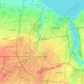
Name: City of Rochester topographic map, elevation, terrain.
Location: City of Rochester, Monroe County, New York, United States (43.10336 -77.70151 43.26773 -77.53251)
Average elevation: 129 m
Minimum elevation: 70 m
Maximum elevation: 213 m
Other topographic maps
Click on a map to view its topography, its elevation and its terrain.
Bushnell's Basin
United States > New York > Monroe County
Bushnell's Basin, Town of Perinton, Monroe County, New York, 14534, United States
Average elevation: 156 m
Town of Clarkson
United States > New York > Monroe County
Town of Clarkson, Monroe County, New York, United States
Average elevation: 125 m
Town of Henrietta
United States > New York > Monroe County
Town of Henrietta, Monroe County, New York, United States
Average elevation: 178 m