
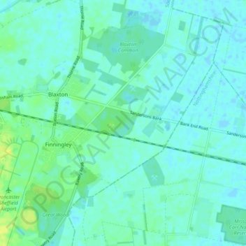
Finningley topographic map
Interactive map
Click on the map to display elevation.
About this map
Name: Finningley topographic map, elevation, terrain.
Average elevation: 4 m
Minimum elevation: -2 m
Maximum elevation: 17 m
Finningley is a village and civil parish in the Metropolitan Borough of Doncaster, in South Yorkshire, England. Historically in Nottinghamshire, it lies on the A614 road about six miles from the centre of Doncaster, at 53°29′N 0°59′W / 53.483°N 0.983°W / 53.483; -0.983 and an elevation of about 23 feet above sea level. The 2001 census gave it a population of 1,442, which rose to 1,497 at the 2011 Census.
Other topographic maps
Click on a map to view its topography, its elevation and its terrain.
Wadworth
United Kingdom > England > Doncaster > Wadworth
Wadworth, Doncaster, Yorkshire and the Humber, England, DN11 9AN, United Kingdom
Average elevation: 41 m
Nottinghamshire
United Kingdom > England > Doncaster
Nottinghamshire, Bankwood Lane, Rossington, Doncaster, Yorkshire and the Humber, England, DN11 0PS, United Kingdom
Average elevation: 74 m