
Richmond County topographic map
Interactive map
Click on the map to display elevation.
About this map
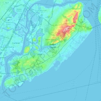
Name: Richmond County topographic map, elevation, terrain.
Location: Richmond County, New York, United States (40.47658 -74.25884 40.65151 -74.03461)
Average elevation: 9 m
Minimum elevation: -5 m
Maximum elevation: 121 m
Although Staten Island is officially an administrative borough of New York City and its coterminous Richmond County is an administrative county of New York State, Staten Island is topographically and geologically a part of New Jersey. Staten Island is separated from Long Island by the Narrows and from mainland New Jersey by the Arthur Kill and the Kill Van Kull. Staten Island is positioned at the center of New York Bight, a sharp bend in the shoreline between New Jersey and Long Island. The region is considered vulnerable to sea-level rise. On October 29, 2012, the island experienced severe damage and loss of life along with the destruction of many homes during Hurricane Sandy.
Other topographic maps
Click on a map to view its topography, its elevation and its terrain.
New York County
United States > New York > New York
New York County, New York, United States
Average elevation: 16 m
The Bronx
United States > New York > New York
The Bronx, New York, United States
Average elevation: 23 m
Hallet’s Cove
United States > New York > New York
Hallet’s Cove, Astoria, Queens, New York, United States
Average elevation: 9 m
Saint John's Park
United States > New York > New York
Saint John's Park, Manhattan Community Board 1, Manhattan, New York County, New York, United States
Average elevation: 11 m
Brooklyn
United States > New York > New York
Brooklyn, Kings County, New York, United States
Average elevation: 9 m
Queens County
United States > New York > New York
Queens County, New York, United States
Average elevation: 11 m