Geolocate

Palermo topographic map

Click on the map to display elevation.

About this map
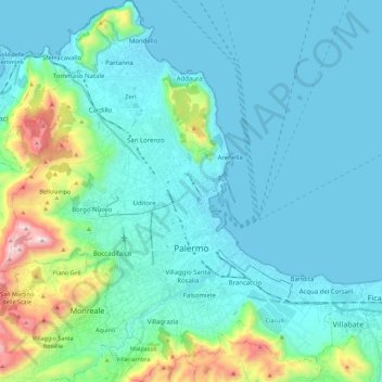
Name: Palermo topographic map, elevation, terrain.

Location: Palermo, Sicily, Italy (38.04991 13.24222 38.22459 13.45209)

Average elevation: 162 m

Minimum elevation: -1 m

Maximum elevation: 1,038 m

Other topographic maps

Click on a map to view its topography, its elevation and its terrain.

Bellacera

Italy > Sicily > Palermo > Santa Flavia

Average elevation: 162 m

Sorgente di Montescuro

Italy > Sicily > Palermo > Prizzi

Average elevation: 831 m

San Carlo

Italy > Sicily > Palermo > Chiusa Sclafani

Average elevation: 291 m

Finale

Italy > Sicily > Palermo

Average elevation: 84 m

Santa Lucia

Italy > Sicily > Palermo > Cefalù

Average elevation: 51 m

Gear up for your next adventure:

🧭Global Orienteering Compass - High-precision liquid-filled compasses for accurate map reading and navigation
📻Handheld UHF Radios - Critical communication for groups in the Australian outback
🎧Bluetooth Outdoor Earbuds - Listen to navigation cues or podcasts during long solo treks
🧯Animal Deterrent Spray - Safety spray for wildlife
🩹Blister Prevention Tape - Apply to friction points before they become painful sores

As an Amazon Associate, this site earns from qualifying purchases at no extra cost to you.