
Coolabine topographic map
Interactive map
Click on the map to display elevation.
About this map
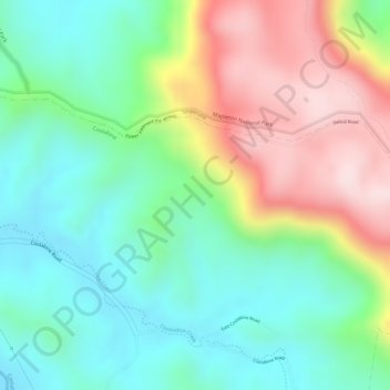
Name: Coolabine topographic map, elevation, terrain.
Location: Coolabine, Maroochydore, Queensland, Australia (-26.60833 152.77444 -26.58833 152.79444)
Average elevation: 241 m
Minimum elevation: 98 m
Maximum elevation: 467 m
Other topographic maps
Click on a map to view its topography, its elevation and its terrain.
Mapleton National Park
Australia > Queensland > Gheerulla
Mapleton National Park, Great Walk, Gheerulla, Queensland, Australia
Average elevation: 200 m