
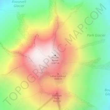
Mount Baker topographic map
Interactive map
Click on the map to display elevation.
About this map
Name: Mount Baker topographic map, elevation, terrain.
Location: Mount Baker, Whatcom County, Washington, United States (48.77670 -121.81461 48.77680 -121.81451)
Average elevation: 2,698 m
Minimum elevation: 2,182 m
Maximum elevation: 3,274 m
Other topographic maps
Click on a map to view its topography, its elevation and its terrain.
Maple Falls
United States > Washington > Whatcom County
Maple Falls, Whatcom County, Washington, United States
Average elevation: 442 m
Ferndale
United States > Washington > Whatcom County
Ferndale, Whatcom County, Washington, United States
Average elevation: 29 m
Skagit River
United States > Washington > Whatcom County
Skagit River, Whatcom County, Washington, United States
Average elevation: 1,391 m
Kloke Peak (Hayden Peak)
United States > Washington > Whatcom County
Kloke Peak (Hayden Peak), Whatcom County, Washington, United States
Average elevation: 1,544 m