
Make a donation
Gear up for your next adventure:
As an Amazon Associate, this site earns from qualifying purchases at no extra cost to you.
Puerto Williams topographic map
Click on the map to display elevation.
Make a donation
Gear up for your next adventure:
As an Amazon Associate, this site earns from qualifying purchases at no extra cost to you.
Puerto Williams
The climate of Puerto Williams is a tundra climate (ET) bordering closely on a subpolar oceanic climate (Cfc) according to the Köppen climate classification. The summers are short and cool while the winters are long, wet, but moderate. Rainfall is around 512.3 mm (20 in) a year and temperatures are steady throughout the year. Snowfall can occur in summer. The cold and wet summers help preserve glaciers. Although the area around the town is well-forested, exposed areas at some distance from or altitude above it have a sub-Antarctic climate typical of tundra, which makes the growth of trees impossible.
Make a donation
Gear up for your next adventure:
As an Amazon Associate, this site earns from qualifying purchases at no extra cost to you.
About this map
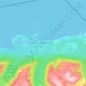
Name: Puerto Williams topographic map, elevation, terrain.
Average elevation: 151 m
Minimum elevation: 0 m
Maximum elevation: 898 m
Make a donation
Gear up for your next adventure:
As an Amazon Associate, this site earns from qualifying purchases at no extra cost to you.