Geolocate

Cockfield topographic map

Click on the map to display elevation.

About this map

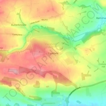
Name: Cockfield topographic map, elevation, terrain.

Location: Cockfield, County Durham, North East, England, United Kingdom (54.60134 -1.84463 54.62596 -1.76196)

Average elevation: 191 m

Minimum elevation: 123 m

Maximum elevation: 259 m

Other topographic maps

Click on a map to view its topography, its elevation and its terrain.

Benfieldside

United Kingdom > England > County Durham > Consett

Average elevation: 179 m

Howden le Wear

United Kingdom > England > County Durham

Average elevation: 150 m

Gear up for your next adventure:

🌬️Windbreaker Jackets - Wind protection jackets
🕯️Emergency Whistles - Safety whistles for hiking
🎒Dry Bags - Waterproof bags for outdoor gear
🧊Insulated Stainless Steel Flasks - Keep water cold for 24 hours in the heat or coffee hot in the cold
🧥Thermal Emergency Blankets - Compact Mylar blankets to prevent hypothermia if stranded overnight

As an Amazon Associate, this site earns from qualifying purchases at no extra cost to you.