Geolocate

Franz Josef topographic map

Click on the map to display elevation.

About this map

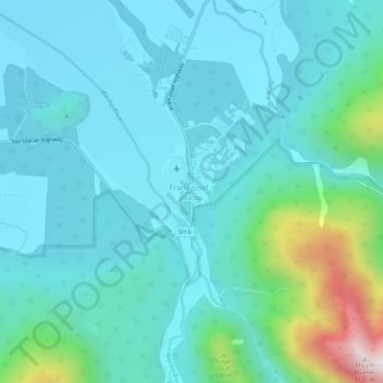
Name: Franz Josef topographic map, elevation, terrain.

Location: Franz Josef, Westland District, West Coast, 7856, New Zealand (-43.40897 170.16190 -43.36897 170.20190)

Average elevation: 277 m

Minimum elevation: 111 m

Maximum elevation: 1,113 m

Other topographic maps

Click on a map to view its topography, its elevation and its terrain.

Franz Josef Glacier

New Zealand > West Coast > Westland District

The névé or snowfield at the head of Franz Josef Glacier is over 2,500 metres (8,200 ft) above sea level and 20 square kilometres (7.7 sq mi) in area. This wide névé, which is over 300 metres (980 ft) deep, feeds large amounts of compacted snow into a steep and narrow valley which drops quickly to very low…

Average elevation: 1,709 m

Perth River

New Zealand > West Coast > Westland District

Average elevation: 918 m

Gear up for your next adventure:

☀️Portable Solar Chargers - High-efficiency panels to hang on your backpack while walking
🔦Powerful LED Headlamps - Hands-free lighting for night navigation and setting up camp after dark
🎒Tactical Waist Packs - Quick access to your compass, phone, and snacks while walking
🧺Fast-Dry Microfiber Towels - Large towels that pack down to the size of an orange
🪢550 Survival Paracord - Versatile cordage for gear repair and emergency lashing

As an Amazon Associate, this site earns from qualifying purchases at no extra cost to you.