
Make a donation
Gear up for your next adventure:
As an Amazon Associate, this site earns from qualifying purchases at no extra cost to you.
Yanqing District topographic map
Click on the map to display elevation.
Make a donation
Gear up for your next adventure:
As an Amazon Associate, this site earns from qualifying purchases at no extra cost to you.
Yanqing District
The Yanqing Badaling Great Wall Basin is surrounded by mountains on three sides in the north, south, east, and Guanting Reservoir to the west, namely the Yanhuai Basin. Yanqing is located in the east of the basin, with an average elevation of about 500 meters. Haituo Mountain is the highest peak in the territory, with an elevation of 2241 meters and the second highest peak in Beijing.
Make a donation
Gear up for your next adventure:
As an Amazon Associate, this site earns from qualifying purchases at no extra cost to you.
About this map
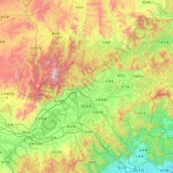
Name: Yanqing District topographic map, elevation, terrain.
Location: Yanqing District, Beijing, 102100, China (40.26430 115.72974 40.78988 116.56832)
Average elevation: 742 m
Minimum elevation: 40 m
Maximum elevation: 2,199 m
Make a donation
Gear up for your next adventure:
As an Amazon Associate, this site earns from qualifying purchases at no extra cost to you.
Other topographic maps
Click on a map to view its topography, its elevation and its terrain.