
London topographic map
Interactive map
Click on the map to display elevation.
About this map
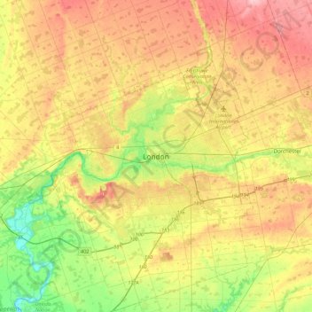
Name: London topographic map, elevation, terrain.
Location: London, Southwestern Ontario, Ontario, N6A 3N7, Canada (42.82324 -81.40337 43.14324 -81.08337)
Average elevation: 269 m
Minimum elevation: 203 m
Maximum elevation: 340 m
London has a humid continental climate (Köppen Dfb), though due to its downwind location relative to Lake Huron and elevation changes across the city, it is virtually on the Dfa/Dfb (hot summer) boundary favouring the former climate zone to the southwest of the confluence of the South and North Thames Rivers, and the latter zone to the northeast (including the airport). Because of its location in the continent, London experiences large seasonal contrast, tempered to a point by the surrounding Great Lakes. The summers are usually warm to hot and humid, with a July average of 20.8 °C (69.4 °F), and temperatures above 30 °C (86 °F) occur on average 10 days per year. In 2016, however, temperatures at or above 30 °C (86 °F) occurred more than 35 times, and in 2018, four heatwave incidents led to humidex temperatures topping out at 46 °C (115 °F) . The city is affected by frequent thunderstorms due to hot, humid summer weather, as well as the convergence of breezes originating from Lake Huron and Lake Erie. The same convergence zone is responsible for spawning funnel clouds and the occasional tornado. Spring and autumn in between are not long, and winters are cold but witness frequent thaws. Annual precipitation averages 1,011.5 mm (39.82 in). Its winter snowfall totals are heavy, averaging about 194 cm (76 in) per year, although the localized nature of snow squalls means the total can vary widely from year to year. Some of the snow accumulation comes from lake effect snow and snow squalls originating from Lake Huron, some 60 km (37 mi) to the northwest, which occurs when strong, cold winds blow from that direction. From 5 December 2010, to 9 December 2010, London experienced record snowfall when up to 2 m (79 in) of snow fell in parts of the city. Schools and businesses were closed for three days and bus service was cancelled after the second day of snow.
Other topographic maps
Click on a map to view its topography, its elevation and its terrain.
Copper Cliff
Canada > Ontario > Sudbury District > Greater Sudbury
Copper Cliff, Greater Sudbury, Sudbury District, Northeastern Ontario, Ontario, P0M 1N0, Canada
Average elevation: 286 m
Garson
Canada > Ontario > Sudbury District > Greater Sudbury
Garson, Greater Sudbury, Sudbury District, Northeastern Ontario, Ontario, P3L 1T7, Canada
Average elevation: 292 m
Bears Back Shoal
Canada > Ontario > Manitoulin District > Northeastern Manitoulin and the Islands
Bears Back Shoal, Northeastern Manitoulin and the Islands, Manitoulin District, Northeastern Ontario, Ontario, Canada
Average elevation: 176 m
Glen Williams
Canada > Ontario > Halton Region
Glen Williams, Halton Hills, Halton Region, Golden Horseshoe, Ontario, L7G 3S8, Canada
Average elevation: 262 m
Middleville
Canada > Ontario > Lanark County > Lanark Highlands
Middleville, Lanark Highlands, Lanark County, Eastern Ontario, Ontario, Canada
Average elevation: 183 m
Alliston
Canada > Ontario > Simcoe County
Alliston, New Tecumseth, Simcoe County, Central Ontario, Ontario, L9R 1A0, Canada
Average elevation: 233 m
Newcastle
Canada > Ontario > Durham Region > Clarington
Newcastle, Clarington, Durham Region, Golden Horseshoe, Ontario, L1B 1L2, Canada
Average elevation: 109 m
Carleton Place
Canada > Ontario > Lanark County
Carleton Place, Lanark County, Eastern Ontario, Ontario, Canada
Average elevation: 137 m
Bigger Lake
Canada > Ontario > Rainy River District > Atikokan
Bigger Lake, Atikokan, Rainy River District, Northwestern Ontario, Ontario, Canada
Average elevation: 410 m
Prescott and Russell
Canada > Ontario > Prescott and Russell Counties
Prescott and Russell, Prescott and Russell Counties, Eastern Ontario, Ontario, Canada
Average elevation: 166 m
Central Huron
Canada > Ontario > Huron County
Central Huron, Huron County, Ontario, Canada
Average elevation: 276 m
Halton Hills
Canada > Ontario > Halton Region
Halton Hills, Halton Region, Golden Horseshoe, Ontario, L7G 5W1, Canada
Average elevation: 287 m
Stormont, Dundas and Glengarry
Canada > Ontario > Stormont, Dundas and Glengarry Counties
Stormont, Dundas and Glengarry, Stormont, Dundas and Glengarry Counties, Eastern Ontario, Ontario, Canada
Average elevation: 153 m
Leeds and Grenville
Canada > Ontario > Leeds and Grenville Counties
Leeds and Grenville, Leeds and Grenville Counties, Eastern Ontario, Ontario, Canada
Average elevation: 146 m
St. Catharines
Canada > Ontario > Niagara Region
St. Catharines, Niagara Region, Golden Horseshoe, Ontario, Canada
Average elevation: 103 m
Gravenhurst
Canada > Ontario > Muskoka District
Gravenhurst, District Municipality of Muskoka, Muskoka District, Central Ontario, Ontario, Canada
Average elevation: 244 m
Kemble
Canada > Ontario > Grey County > Georgian Bluffs
Kemble, Georgian Bluffs, Grey County, Ontario, Canada
Average elevation: 243 m
Keewatin Park
Canada > Ontario > Durham Region > Oshawa
Keewatin Park, 105, Harmony, Oshawa, Durham Region, Golden Horseshoe, Ontario, Canada
Average elevation: 117 m
Midland
Canada > Ontario > Simcoe County
Midland, Simcoe County, Central Ontario, Ontario, Canada
Average elevation: 209 m
Tamworth
Canada > Ontario > Lennox and Addington County > Stone Mills
Tamworth, Stone Mills, Lennox and Addington County, Eastern Ontario, Ontario, K0K 3G0, Canada
Average elevation: 166 m
Hamilton Township
Canada > Ontario > Northumberland County
Hamilton Township, Northumberland County, Central Ontario, Ontario, Canada
Average elevation: 192 m
Cambridge
Canada > Ontario > Region of Waterloo
Cambridge, Region of Waterloo, Ontario, Canada
Average elevation: 304 m
Milverton
Canada > Ontario > Perth County > Perth East
Milverton, Perth East, Perth County, Ontario, N0K 1M0, Canada
Average elevation: 377 m
Rhonda Park
Canada > Ontario > Durham Region > Clarington > Bowmanville
Rhonda Park, Bowmanville, Clarington, Durham Region, Golden Horseshoe, Ontario, Canada
Average elevation: 105 m
Willowdale
Willowdale, North York, Toronto, Ontario, Canada
Average elevation: 179 m
Port Dover
Canada > Ontario > Norfolk County
Port Dover, Norfolk County, Southwestern Ontario, Ontario, N0A 1N0, Canada
Average elevation: 187 m
Wasaga Beach Provincial Park
Canada > Ontario > Simcoe County > Wasaga Beach
Wasaga Beach Provincial Park, Wasaga Beach, Simcoe County, Central Ontario, Ontario, L9Z 2V9, Canada
Average elevation: 185 m
Lindsay
Canada > Ontario > Kawartha Lakes
Lindsay, Kawartha Lakes, Central Ontario, Ontario, K9V 2Y5, Canada
Average elevation: 268 m
Ajax
Canada > Ontario > Durham Region
Ajax, Durham Region, Golden Horseshoe, Ontario, Canada
Average elevation: 101 m
Cardiff
Canada > Ontario > Haliburton County > Highlands East
Cardiff, Highlands East, Haliburton County, Central Ontario, Ontario, K0L 1M0, Canada
Average elevation: 366 m
Walkerton
Canada > Ontario > Bruce County > Brockton
Walkerton, Brockton, Bruce County, Southwestern Ontario, Ontario, N0G 2V0, Canada
Average elevation: 286 m
Biscotasi Lake
Canada > Ontario > Sudbury District > Unorganized North Sudbury
Biscotasi Lake, Unorganized North Sudbury, Sudbury District, Northeastern Ontario, Ontario, Canada
Average elevation: 416 m
North Dumfries
Canada > Ontario > Region of Waterloo
North Dumfries, Region of Waterloo, Southwestern Ontario, Ontario, Canada
Average elevation: 297 m
Talbotville
Canada > Ontario > Elgin County > Southwold
Talbotville, Southwold, Elgin County, Southwestern Ontario, Ontario, N5P 3T2, Canada
Average elevation: 234 m
Haliburton County
Haliburton County, Central Ontario, Ontario, Canada
Average elevation: 392 m
Kemptville
Canada > Ontario > Leeds and Grenville Counties > North Grenville
Kemptville, North Grenville, Leeds and Grenville Counties, Eastern Ontario, Ontario, K0G 1J0, Canada
Average elevation: 97 m
Brockville
Canada > Ontario > Brockville
Brockville, Eastern Ontario, Ontario, K6V 3P9, Canada
Average elevation: 103 m
Belleville
Canada > Ontario > Belleville
Belleville, Central Ontario, Ontario, K8N 2Z2, Canada
Average elevation: 107 m
Greater Sudbury
Canada > Ontario > Sudbury District
Greater Sudbury, Sudbury District, Northeastern Ontario, Ontario, Canada
Average elevation: 305 m