Geolocate

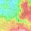
Fulda topographic map

Click on the map to display elevation.

About this map
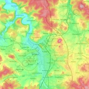
Name: Fulda topographic map, elevation, terrain.

Location: Fulda, Landkreis Fulda, Hesse, Germany (50.49954 9.56614 50.62941 9.73298)

Average elevation: 324 m

Minimum elevation: 225 m

Maximum elevation: 470 m

Other topographic maps

Click on a map to view its topography, its elevation and its terrain.
Milseburg

Germany > Hesse > Landkreis Fulda

The Milseburg is an extinct volcano and at 835 metres (2,740 ft) above sea level the second highest elevation in the Hessian part of the Rhön Mountains, Germany. The hill is located east of Fulda, near the villages of Kleinsassen and Danzwiesen. It is a popular destination for hikers and bikers.…

Average elevation: 619 m
Oberbernhards

Germany > Hesse > Landkreis Fulda > Liebhards

Average elevation: 579 m

Erlenhof

Germany > Hesse > Landkreis Fulda

Average elevation: 306 m

Branders

Germany > Hesse > Landkreis Fulda > Buchenau

Average elevation: 344 m

Gear up for your next adventure:

📡Satellite Messengers - Emergency communication devices
👕UPF 50+ Sun Shirts - Essential protection against the harsh Australian sun during field work
🥤Hydration Packs - Hydration systems for hiking
🧼Biodegradable Outdoor Soap - Clean gear and yourself without harming the local ecosystem
🆘Personal Locator Beacons (PLB) - Satellite emergency beacons for life-saving help in areas with no mobile coverage

As an Amazon Associate, this site earns from qualifying purchases at no extra cost to you.