Geolocate

Truro topographic map

Click on the map to display elevation.

About this map
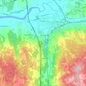
Name: Truro topographic map, elevation, terrain.

Location: Truro, Town of Truro, Colchester County, Nova Scotia, Canada (45.30842 -63.30863 45.38406 -63.19335)

Average elevation: 73 m

Minimum elevation: -2 m

Maximum elevation: 185 m

Other topographic maps

Click on a map to view its topography, its elevation and its terrain.

McClures Mills

Canada > Nova Scotia > Town of Truro > Truro

Average elevation: 46 m

Victoria Park

Canada > Nova Scotia > Town of Truro > Truro

Average elevation: 58 m

McClures Mills

Canada > Nova Scotia > Town of Truro > Truro

Average elevation: 46 m

Victoria Park

Canada > Nova Scotia > Town of Truro > Truro

Average elevation: 58 m

Victoria Park

Canada > Nova Scotia > Town of Truro > Truro

Average elevation: 58 m

Harmony Road

Canada > Nova Scotia > Town of Truro > Truro

Average elevation: 127 m

Victoria Park

Canada > Nova Scotia > Town of Truro > Truro

Average elevation: 58 m

Gear up for your next adventure:

🪑Portable Backpacking Chairs - A comfortable seat for studying maps at the end of the day
🛠️Outdoor Repair Kits - Gear repair kits
📖Australian Bush Survival Books - Local knowledge on finding water and surviving the outback
🔦Headlamps - Hands-free lighting for hiking
🧥Softshell Jackets - Flexible outdoor jackets

As an Amazon Associate, this site earns from qualifying purchases at no extra cost to you.