Geolocate

Pacific topographic map

Click on the map to display elevation.

About this map

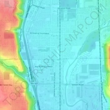
Name: Pacific topographic map, elevation, terrain.

Location: Pacific, King County, Washington, United States (47.24287 -122.27157 47.27411 -122.22850)

Average elevation: 39 m

Minimum elevation: 14 m

Maximum elevation: 125 m

Gear up for your next adventure:

Outdoor Coffee Makers - Enjoy quality coffee at the summit of your favorite peak
📡Satellite Messengers - Emergency communication devices
🚁Camera Drones with GPS - Capture aerial views of the landscape to compare with topo maps
👕UPF 50+ Sun Shirts - Essential protection against the harsh Australian sun during field work
🧦Hiking Socks - Comfortable socks for long hikes

As an Amazon Associate, this site earns from qualifying purchases at no extra cost to you.