Geolocate

Waianae topographic map

Click on the map to display elevation.

About this map

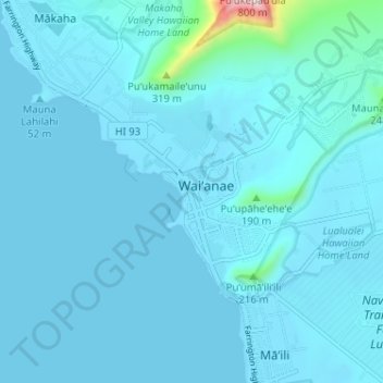
Name: Waianae topographic map, elevation, terrain.

Location: Waianae, Honolulu County, Hawaii, 96792, United States (21.42664 -158.21466 21.46488 -158.15042)

Average elevation: 40 m

Minimum elevation: 0 m

Maximum elevation: 732 m

Gear up for your next adventure:

🧦Hiking Socks - Comfortable socks for long hikes
🔦Headlamps - Hands-free lighting for hiking
📡Portable Emergency Radios - Stay informed about weather warnings and bushfire alerts
📷Backpack Camera Clips - Quick access to your camera while keeping your hands free for climbing
🥾Hiking Boots - Durable hiking boots for trails and rough terrain

As an Amazon Associate, this site earns from qualifying purchases at no extra cost to you.