
Fako topographic map
Interactive map
Click on the map to display elevation.
About this map
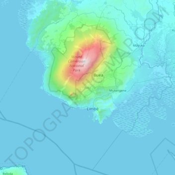
Name: Fako topographic map, elevation, terrain.
Location: Fako, Southwest, Cameroon (3.74371 8.79192 4.46054 9.55541)
Average elevation: 232 m
Minimum elevation: -5 m
Maximum elevation: 4,007 m
Other topographic maps
Click on a map to view its topography, its elevation and its terrain.
Ikiliwindi Mile 12
Cameroon > Southwest > Meme > Kumba II > Ikiliwindi Mile 12
Ikiliwindi Mile 12, Kumba II, Communauté urbaine de Kumba, Meme, Southwest, Cameroon
Average elevation: 288 m
Mount Manenguba
Cameroon > Southwest > Kupe-Muanenguba > Bangem
Mount Manenguba, Bangem, Kupe-Muanenguba, Southwest, Cameroon
Average elevation: 2,112 m