
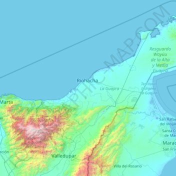
La Guajira topographic map
Interactive map
Click on the map to display elevation.
About this map
Name: La Guajira topographic map, elevation, terrain.
Location: La Guajira, RAP Caribe, Colombia (10.39671 -73.66464 12.45733 -71.11296)
Average elevation: 290 m
Minimum elevation: -6 m
Maximum elevation: 5,519 m
The department was divided into three subregions based on geographical characteristics: Upper, Middle, and Southern Guajira. The Upper Guajira covers the northernmost part of the peninsula, with mostly scarce semi-desertic vegetation. It has only an isolated, low-altitude mountain range, the Serranía de Macuira (865 m above sea level). The Middle Guajira region is mostly flat, with hills in some areas, presenting also an arid environment. The Southern Guajira covers the region of the Montes de Oca and the Serranía del Perijá mountain ranges on the border with Venezuela, and the valley formed with the Sierra Nevada de Santa Marta mountain range. Southern Guajira has more green vegetation, wetlands and rivers.
Other topographic maps
Click on a map to view its topography, its elevation and its terrain.
Bogota, Capital District
Bogota, Capital District, RAP (Especial) Central, Colombia
Average elevation: 2,183 m
Perimetro Urbano Pereira
Perimetro Urbano Pereira, Pereira, Risaralda, RAP Eje Cafetero, Colombia
Average elevation: 1,486 m
Palmira
Palmira, Sur, Valle del Cauca, RAP Pacífico, Colombia
Average elevation: 1,600 m
Cali
Colombia > Valle del Cauca > Cali
Cali, Sur, Valle del Cauca, RAP Pacífico, Colombia
Average elevation: 1,140 m
Comuna 4
Colombia > Valle del Cauca > Perímetro Urbano Santiago de Cali
Comuna 4, Perímetro Urbano Santiago de Cali, Cali, Sur, Valle del Cauca, Colombia
Average elevation: 964 m
Perímetro Urbano Barranquilla
Colombia > Atlántico > Barranquilla
Perímetro Urbano Barranquilla, Barranquilla, Atlántico, Colombia
Average elevation: 29 m
Olaya Herrera (Bocas de Satinga)
Colombia > Nariño > Olaya Herrera (Bocas de Satinga)
Olaya Herrera (Bocas de Satinga), Sanquianga, Nariño, Colombia
Average elevation: 13 m
Villa de Leyva
Colombia > Boyacá > Villa de Leyva
Villa de Leyva, Ricaurte, Boyacá, Colombia
Average elevation: 2,416 m
Cove Road
Colombia > Archipiélago de San Andrés, Providencia y Santa Catalina > San Andrés > Cove Road
Cove Road, San Andrés, Archipiélago de San Andrés, Providencia y Santa Catalina, Colombia
Average elevation: 12 m
Bucaramanga
Colombia > Santander > Bucaramanga
Bucaramanga, Santander, Colombia
Average elevation: 1,196 m
Bogota Capital District
Colombia > Bogota Capital District
Bogota Capital District, 11001, Colombia
Average elevation: 2,183 m
Kennedy
Colombia > Bogota Capital District > Kennedy
Kennedy, Bogota, Bogota Capital District, Colombia
Average elevation: 2,550 m
San Francisco
San Francisco, Recetor, Casanare, Colombia
Average elevation: 1,463 m