
Kaunertal topographic map
Interactive map
Click on the map to display elevation.
About this map
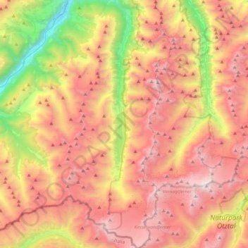
Name: Kaunertal topographic map, elevation, terrain.
Location: Kaunertal, Bezirk Landeck, Tyrol, 6524, Austria (46.82251 10.66156 47.07185 10.82162)
Average elevation: 2,399 m
Minimum elevation: 869 m
Maximum elevation: 3,726 m
The Kaunertal valley is 28 km (17 mi) in length and runs southeast from the town of Prutz (884 m) to the Kaunertal Glacier. The valley is traversed by the Faggenbach river, which rises south of the Weißseespitze mountain (3044 m) and flows into the Inn river at Prutz (884 m), the site of a hydroelectric power station. The Gepatsch Reservoir (Gepatsch Stausee), which is located on the upper course of the Fagge river, is 6 km (3.7 mi) in length, has a capacity of 138,000,000 m3, and is formed by a rockfill dam that is 630 m (2,070 ft) long and 130 m (430 ft) high. The dam was constructed in 1961. Water from the lake is used to generate electricity through a pipe system 13 km (8.1 mi) in length, located at the south end of the Kaunertal. The generator facility at Prutz produces 620 million kilowatt hours per year. The lake surface is at an altitude of 1,820 m (5,970 ft).