Geolocate

York topographic map

Click on the map to display elevation.

About this map

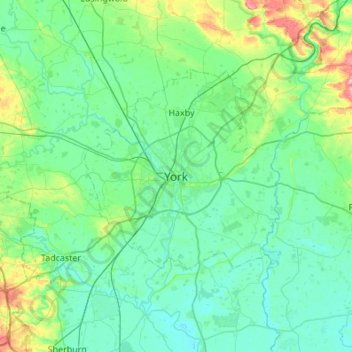
Name: York topographic map, elevation, terrain.

Location: York, England, YO1 8RS, United Kingdom (53.79906 -1.24154 54.11906 -0.92154)

Average elevation: 21 m

Minimum elevation: 1 m

Maximum elevation: 123 m

Gear up for your next adventure:

🧺Waterproof Dry Sacks - Organize your pack and keep electronics safe from rain and river crossings
📡Satellite Messengers - Emergency communication devices
🧭Military Style Lensatic Compass - Durable sighting compasses for advanced land navigation and surveying
🛠️Outdoor Repair Kits - Gear repair kits
🎒Tactical Waist Packs - Quick access to your compass, phone, and snacks while walking

As an Amazon Associate, this site earns from qualifying purchases at no extra cost to you.