
Make a donation
Gear up for your next adventure:
As an Amazon Associate, this site earns from qualifying purchases at no extra cost to you.
Novato topographic map
Click on the map to display elevation.
Make a donation
Gear up for your next adventure:
As an Amazon Associate, this site earns from qualifying purchases at no extra cost to you.
About this map
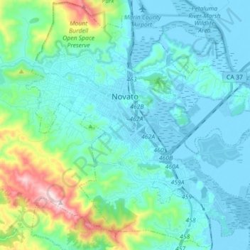
Name: Novato topographic map, elevation, terrain.
Location: Novato, Marin County, California, United States (38.03948 -122.62378 38.14798 -122.48367)
Average elevation: 97 m
Minimum elevation: -6 m
Maximum elevation: 572 m
Make a donation
Gear up for your next adventure:
As an Amazon Associate, this site earns from qualifying purchases at no extra cost to you.
Other topographic maps
Click on a map to view its topography, its elevation and its terrain.
Marshall
United States > California > Marin County
Marshall is an unincorporated community in Marin County, California. It is located on the northeast shore of Tomales Bay 6 mi (9.7 km) south of Tomales, at an elevation of 25 ft (7.6 m).
Average elevation: 51 m