Geolocate

Sitges topographic map

Interactive map

Click on the map to display elevation.

About this map

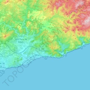
Name: Sitges topographic map, elevation, terrain.

Location: Sitges, Garraf, Barcelona, Cataluña, 08870, España (41.21859 1.75620 41.29101 1.94455)

Average elevation: 130 m

Minimum elevation: -1 m

Maximum elevation: 591 m

Other topographic maps

Click on a map to view its topography, its elevation and its terrain.

Vilanova y Geltrú

España > Cataluña > Garraf

Vilanova y Geltrú, Garraf, Barcelona, Cataluña, 08800, España

Average elevation: 74 m

el Turonet

España > Cataluña > Garraf > Sitges

el Turonet, Sitges, Garraf, Barcelona, Cataluña, 08870, España

Average elevation: 228 m