
Make a donation
Gear up for your next adventure:
As an Amazon Associate, this site earns from qualifying purchases at no extra cost to you.
Vera topographic map
Click on the map to display elevation.
Make a donation
Gear up for your next adventure:
As an Amazon Associate, this site earns from qualifying purchases at no extra cost to you.
About this map
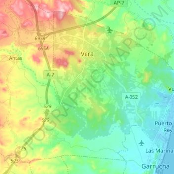
Name: Vera topographic map, elevation, terrain.
Location: Vera, Almeria, Andalusia, Spain (37.18733 -1.91848 37.27104 -1.79713)
Average elevation: 69 m
Minimum elevation: -2 m
Maximum elevation: 208 m
Make a donation
Gear up for your next adventure:
As an Amazon Associate, this site earns from qualifying purchases at no extra cost to you.
Other topographic maps
Click on a map to view its topography, its elevation and its terrain.
Mijas
Spain > Andalusia > Costa del Sol Occidental > Mijas > Mijas
The climate changes gradually with increasing elevation in the mountains. Temperatures can drop to 10 °C (50 °F). In the peaks, over 600 m (2,000 ft) high, some ice may form in winter, while precipitation increases to almost 800 mm (32 in).
Average elevation: 447 m
Make a donation
Gear up for your next adventure:
As an Amazon Associate, this site earns from qualifying purchases at no extra cost to you.
Park Beach
Spain > Andalusia > Costa del Sol Occidental > Estepona > Park Beach
Average elevation: 13 m