Geolocate

New Hanover Island topographic map

Click on the map to display elevation.

About this map
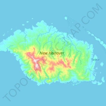
Name: New Hanover Island topographic map, elevation, terrain.

Location: New Hanover Island, Lamet District, New Ireland, Islands Region, Papua New Guinea (-2.68068 149.94278 -2.35807 150.46345)

Average elevation: 55 m

Minimum elevation: 0 m

Maximum elevation: 865 m

Other topographic maps

Click on a map to view its topography, its elevation and its terrain.

Putput

Papua New Guinea > New Ireland

Average elevation: 3 m

Putput

Papua New Guinea > New Ireland

Average elevation: 69 m

Ramat

Papua New Guinea > New Ireland

Average elevation: 71 m

Nokon

Papua New Guinea > New Ireland

Average elevation: 27 m

Kavieng

Papua New Guinea > New Ireland

Average elevation: 3 m

Kavieng

Papua New Guinea > New Ireland

Average elevation: 2 m

Malom

Papua New Guinea > New Ireland

Average elevation: 74 m

Kono

Papua New Guinea > New Ireland

Average elevation: 84 m

Gear up for your next adventure:

🎒Tactical Waist Packs - Quick access to your compass, phone, and snacks while walking
🔥Camping Stoves - Portable stoves for outdoor cooking
🥾Hiking Shoes - Lightweight hiking shoes for day hikes
🩹Wilderness First Aid Kits - Comprehensive medical kits tailored for hiking and remote exploration
🔦LED Torches - LED torches for outdoor use

As an Amazon Associate, this site earns from qualifying purchases at no extra cost to you.