
Make a donation
Gear up for your next adventure:
As an Amazon Associate, this site earns from qualifying purchases at no extra cost to you.
Ermera topographic map
Click on the map to display elevation.
Make a donation
Gear up for your next adventure:
As an Amazon Associate, this site earns from qualifying purchases at no extra cost to you.
About this map
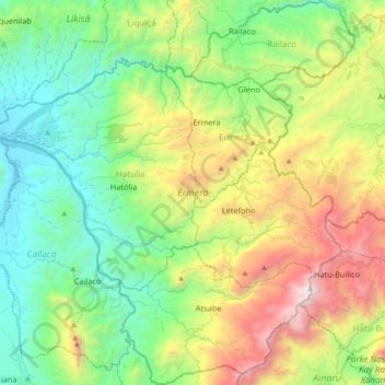
Name: Ermera topographic map, elevation, terrain.
Location: Ermera, East Timor (-8.99607 125.19070 -8.63827 125.53542)
Average elevation: 915 m
Minimum elevation: 37 m
Maximum elevation: 2,935 m
Make a donation
Gear up for your next adventure:
As an Amazon Associate, this site earns from qualifying purchases at no extra cost to you.
Other topographic maps
Click on a map to view its topography, its elevation and its terrain.
Mount Ramelau
The Ramelau Mountain Range is the result of orogenic forces due to the collision of Australia and Asian tectonic plates. The tallest mountain in the Ramelau Mountain Range is made of mafic volcanic deposits related to intra-cratonic rifting, called the Maubisse Formation, deposited in the Permian. This is one…
Average elevation: 2,486 m