
Haverhill topographic map
Click on the map to display elevation.
About this map
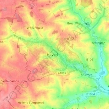
Name: Haverhill topographic map, elevation, terrain.
Average elevation: 93 m
Minimum elevation: 49 m
Maximum elevation: 131 m
Other topographic maps
Click on a map to view its topography, its elevation and its terrain.
Bury St Edmunds
United Kingdom > England > Suffolk > West Suffolk
The name Bury is etymologically connected with borough, which has cognates in other Germanic languages such as German Burg 'fortress, castle' and Bereich '(defined) area' Old Norse borg 'wall, castle'; and Gothic baurg 'city'. They all derive from Proto-Germanic *burgs 'fortress'. This in turn derives from the…
Average elevation: 54 m